Historical Mine Subsidence Investigation
CSR GeoSurveys Ltd. was contracted to conduct a geophysical survey in eastern Nova Scotia to assess potential subsidence concerns related to historic coal mining. The objective of the survey was to locate potential mine shafts and associated subsurface anomalies using ground penetrating radar (GPR) and ground magnetometer methods to support subsurface hazard assessment and land use evaluation.
Survey Methods
The investigation employed non-destructive geophysical methods to characterize subsurface conditions across three main survey areas, including:
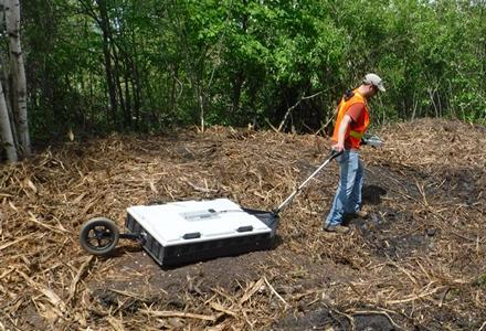
- Ground Penetrating Radar (GPR): A MALA Ground Explorer GPR system, operated at a frequency of 80MHz, was used to identify subsurface voids, disturbed ground, and buried structural features potentially associated with abandoned mine workings.
- Ground Magnetometry: A GSM-19 Overhauser magnetometer was used to detect buried metallic features and anomalous magnetic responses associated with mine shaft capping materials and infrastructure remnants.
Survey data were collected along dense grid patterns with 2 m line spacing, providing high-resolution coverage across the investigation areas.
Data Interpretation & Results
The geophysical datasets identified multiple anomalous responses consistent with buried infrastructure, disturbed ground, and potential abandoned mine workings across the survey areas. Several locations exhibited coincident magnetic and GPR anomalies, which were interpreted as being consistent with potential shaft locations or engineered subsurface structures associated with historical mining activity. These responses were further supported by observed surface conditions, including subsidence features and localized ground disturbance.
The combined GPR and magnetic results provided a high-resolution assessment of the subsurface variability and supported the identification of priority areas for further investigation and risk evaluation related to historic mine workings.
Gallery


Over 350 survey lines were collected with the ground magnetometer and GPR across the three survey sites.
- Large Scale Magnetic Clearance Project
- Damage Prevention Investigation
- Bridge Concrete Foundation Assessment
- Wind Farm Seismic Site Classification
- Historical Mine Subsidence Investigation
- Concrete Slab GPR Investigation
- EM61 MAPPING, DND Naval Engineering School
- EM61 MAPPING, Department of National Defence