Damage Prevention Investigation
CSR GeoSurveys Ltd. coducted a damage prevention investigation at a facility in eastern Nova Scotia to support planned ground disturbance activities. The investigation was conducted to identify and map buried utilities, subsurface structures, and potential hazards within the survey site. CSR also collected positional information for previously identified features that were located using traditional electromagnetic (EM) based utility locating methods.
Survey Methods
The investigation incorporated non-intrusive geophysical and positioning methods to map and characterize shallow subsurface features, including:
- Ground Penetrating Radar (GPR): A Sensors & Software pulseEKKO GPR system, assembled in a cart-based configuration, was used to identify subsurface anomalous features. A 500 MHz antenna frequency was utilized based on anticipated target depth, size, and site ground conditions.
- RTK-GNSS: A Spectra Precision SP80 RTK-GNSS rover was used to provide accurate georeferencing of GPR data and positional information for the identified subsurface features.
GPR data were collected within controlled 15 m x 15 m survey grids with 1 m line spacing in both north-south and east-west orientations to ensure full coverage of the investigation area.
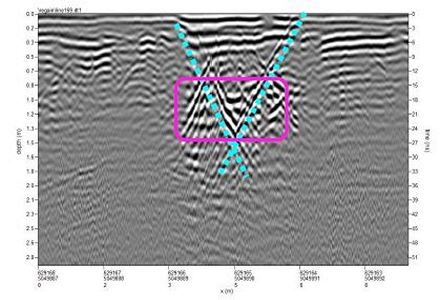
Data Interpretation & Results
The GPR survey provided effective subsurface imaging to depths of approximately 1.5 - 2.0 m, depending on ground conditions. Within this depth range, several anomalous responses consistent with buried infrastructure and subsurface features were identified across the survey grids. Interpretation of the GPR data was supported through correlation with utility locations that were identified during the EM survey.
The investigation provided spatially referenced subsurface information to support utility avoidance, damage prevention planning, and safe ground disturbance activities within the survey site.
Gallery


Preliminary interpretation of the GPR data was conducted in real time to allow for identified subsurface features to be marked directly on the ground surface using colour coded paint.
- Large Scale Magnetic Clearance Project
- Damage Prevention Investigation
- Bridge Concrete Foundation Assessment
- Wind Farm Seismic Site Classification
- Historical Mine Subsidence Investigation
- Concrete Slab GPR Investigation
- EM61 MAPPING, DND Naval Engineering School
- EM61 MAPPING, Department of National Defence