Concrete Slab GPR Investigation
CSR GeoSurveys Ltd. completed a ground penetrating radar (GPR) investigation at a facility in southwestern New Brunswick. The purpose of the investigation was to identify and map potential sub-slab voiding and provide information pertaining to the reinforcement layout and coverage of a concrete slab.
Geophysical Investigation
GPR data acquisition was completed using a Sensors & Software pulseEKKO control unit in conjunction with a 1000 MHz frequency antenna. This lower frequency antenna was selected based on anticipated slab thickness, reinforcement density, and existing concrete condition within the investigation area. The GPR system was assembled in a tow-behind configuration to improve efficiency of data collection and to facilitate navigation around obstructions within the survey area.
GPR data were collected within accessible portions of the 50 m x 12 m concrete slab investigation area. Survey lines were spaced at 1 m intervals and oriented parallel and perpendicular to the facility walls.
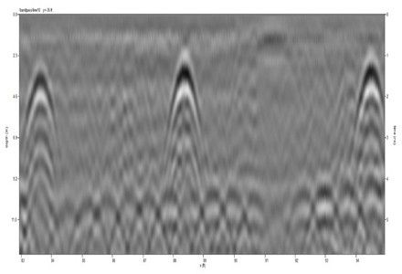
Data Interpretation & Results
The GPR data identified a regular pattern of north-south oriented reinforcement arranged in upper, middle, and lower layers within the concrete slab. In addition, several anomalous subsurface responses were identified that may indicate localized sub-slab voiding, poor compaction of base materials, or changes in subsurface composition beneath portions of the slab.
The results of the investigation supported evaluation of slab conditions and provided information for ongoing engineering assessments and maintenance planning.
Gallery


A total of 760 m of GPR data were collected across 96 individual survey lines within the investigation area.
- Large Scale Magnetic Clearance Project
- Damage Prevention Investigation
- Bridge Concrete Foundation Assessment
- Wind Farm Seismic Site Classification
- Historical Mine Subsidence Investigation
- Concrete Slab GPR Investigation
- EM61 MAPPING, DND Naval Engineering School
- EM61 MAPPING, Department of National Defence